Web cookies (also called HTTP cookies, browser cookies, or simply cookies) are small pieces of data that websites store on your device (computer, phone, etc.) through your web browser. They are used to remember information about you and your interactions with the site.
Session Management:
Keeping you logged in
Remembering items in a shopping cart
Saving language or theme preferences
Personalization:
Tailoring content or ads based on your previous activity
Tracking & Analytics:
Monitoring browsing behavior for analytics or marketing purposes
Session Cookies:
Temporary; deleted when you close your browser
Used for things like keeping you logged in during a single session
Persistent Cookies:
Stored on your device until they expire or are manually deleted
Used for remembering login credentials, settings, etc.
First-Party Cookies:
Set by the website you're visiting directly
Third-Party Cookies:
Set by other domains (usually advertisers) embedded in the website
Commonly used for tracking across multiple sites
Authentication cookies are a special type of web cookie used to identify and verify a user after they log in to a website or web application.
Once you log in to a site, the server creates an authentication cookie and sends it to your browser. This cookie:
Proves to the website that you're logged in
Prevents you from having to log in again on every page you visit
Can persist across sessions if you select "Remember me"
Typically, it contains:
A unique session ID (not your actual password)
Optional metadata (e.g., expiration time, security flags)
Analytics cookies are cookies used to collect data about how visitors interact with a website. Their primary purpose is to help website owners understand and improve user experience by analyzing things like:
How users navigate the site
Which pages are most/least visited
How long users stay on each page
What device, browser, or location the user is from
Some examples of data analytics cookies may collect:
Page views and time spent on pages
Click paths (how users move from page to page)
Bounce rate (users who leave without interacting)
User demographics (location, language, device)
Referring websites (how users arrived at the site)
Here’s how you can disable cookies in common browsers:
Open Chrome and click the three vertical dots in the top-right corner.
Go to Settings > Privacy and security > Cookies and other site data.
Choose your preferred option:
Block all cookies (not recommended, can break most websites).
Block third-party cookies (can block ads and tracking cookies).
Open Firefox and click the three horizontal lines in the top-right corner.
Go to Settings > Privacy & Security.
Under the Enhanced Tracking Protection section, choose Strict to block most cookies or Custom to manually choose which cookies to block.
Open Safari and click Safari in the top-left corner of the screen.
Go to Preferences > Privacy.
Check Block all cookies to stop all cookies, or select options to block third-party cookies.
Open Edge and click the three horizontal dots in the top-right corner.
Go to Settings > Privacy, search, and services > Cookies and site permissions.
Select your cookie settings from there, including blocking all cookies or blocking third-party cookies.
For Safari on iOS: Go to Settings > Safari > Privacy & Security > Block All Cookies.
For Chrome on Android: Open the app, tap the three dots, go to Settings > Privacy and security > Cookies.
Disabling cookies can make your online experience more difficult. Some websites may not load properly, or you may be logged out frequently. Also, certain features may not work as expected.
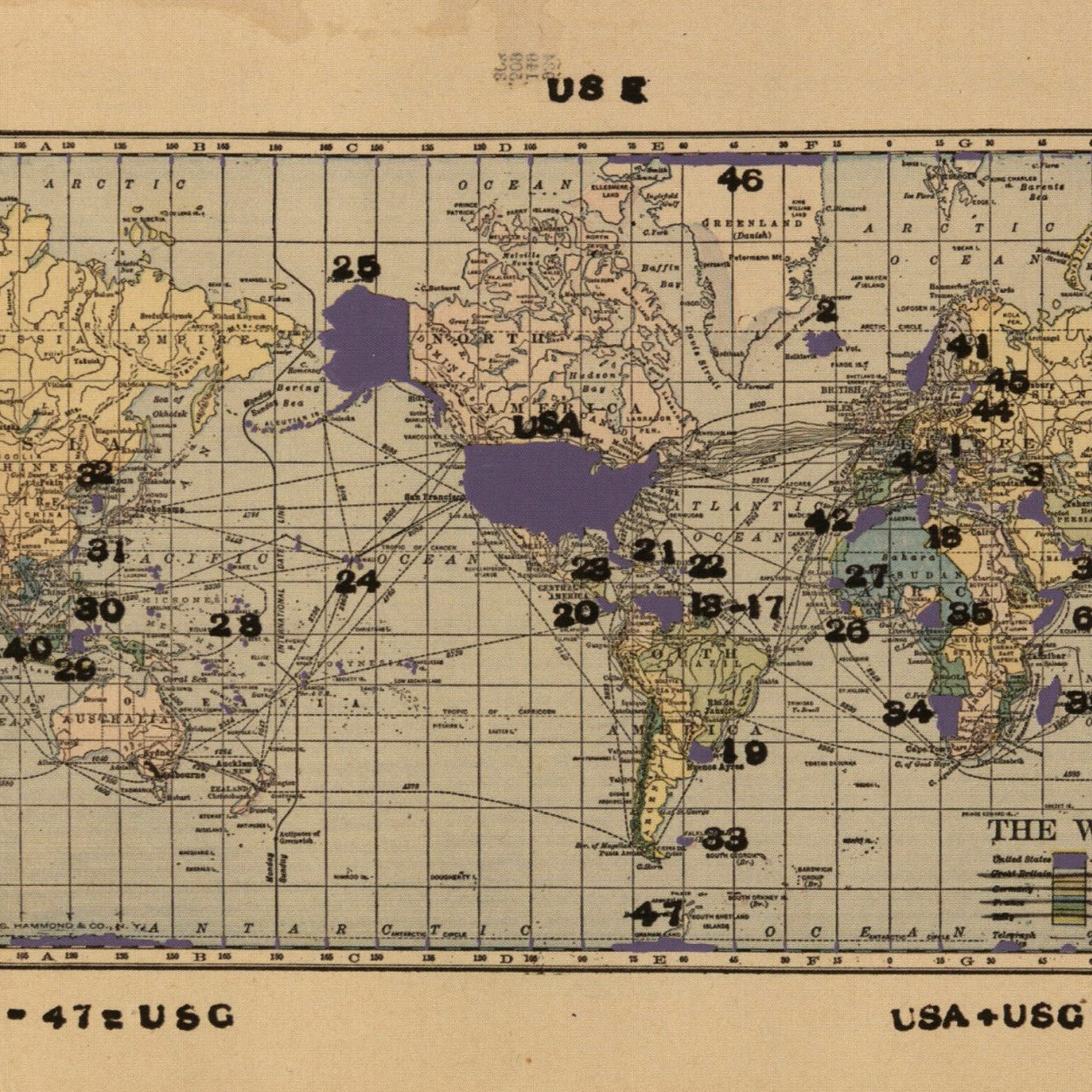
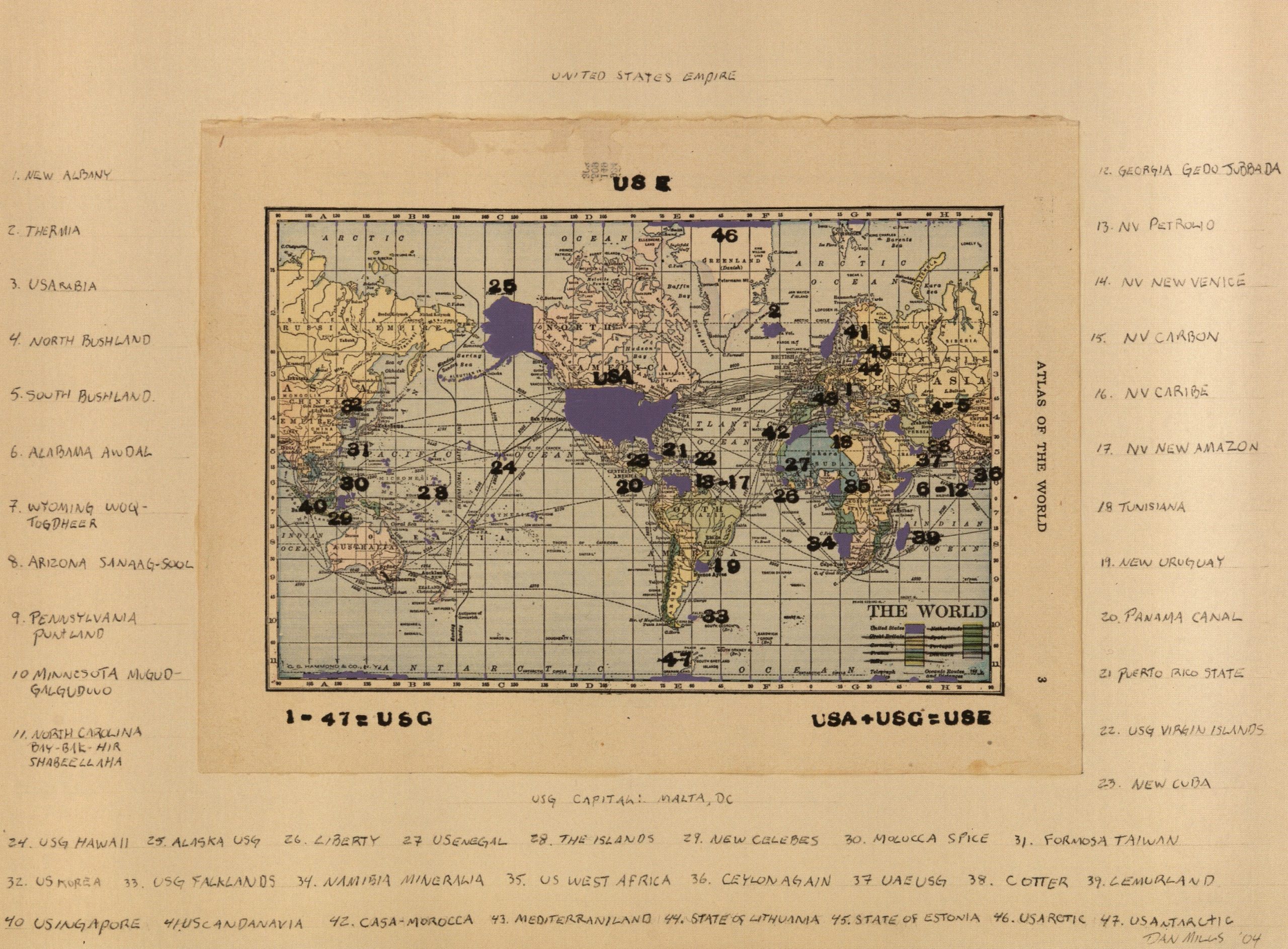
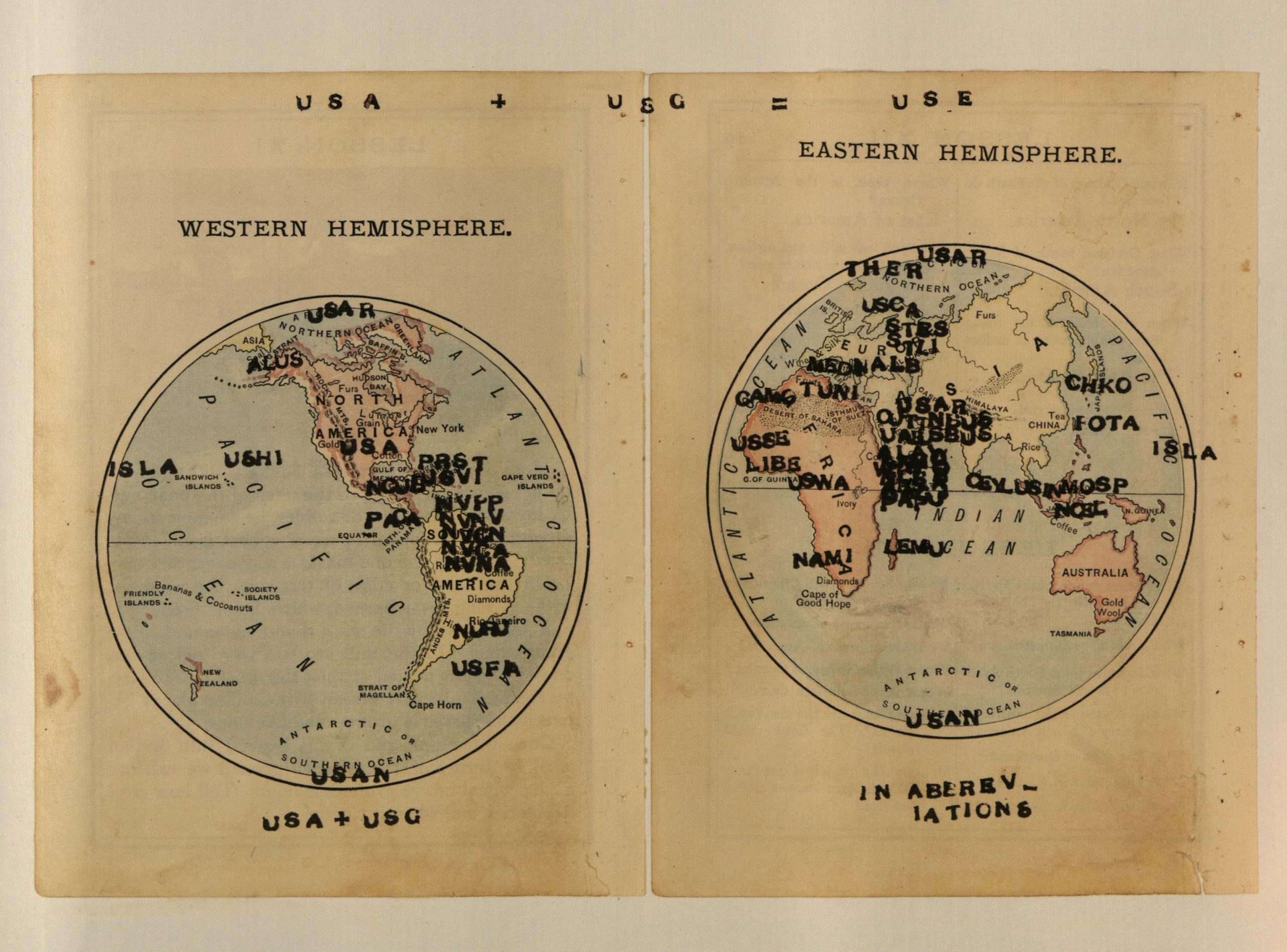
US Future States Atlas: an Atlas of Global Imperialism
Daniel T. Mills and Phong Bui
2009
Santa Monica, CA
Perceval Press
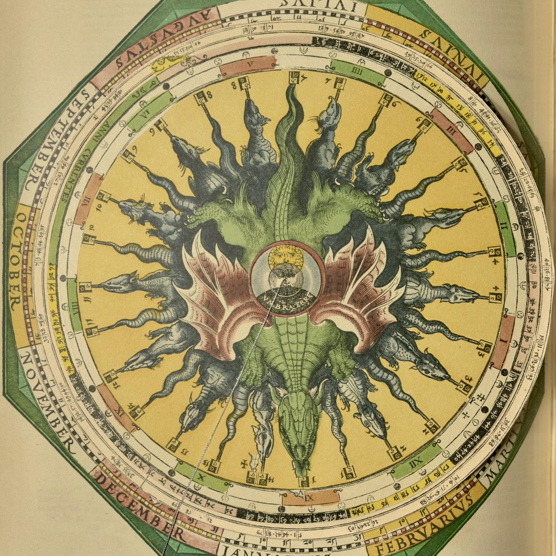
Daniel Mills’s US Future States Atlas, like Enrique Chagoya’s Road Map, provides an exploration and interrogation of American imperialism. Introducing the project Mills writes, “[T]he atlas was started in response to the then U.S. leaders’ increasingly aggressive interactions with many countries—there were indications that the U.S. government would go to war, invade, or threaten other nations for a variety of reasons such as wanting their resources, not liking their leader, thinking they had weapons of mass destruction” (2009: 1).
Mills views his project as extending the US’s imperialistic logic to its reaches. The complete Atlas includes in-depth examinations of each potential future state, focusing on an explanation of the United State’s “Motive/Rationale for Takeover & Future Statehood” and “Benefits to Us.” Here, you see three different map designs depicting the Earth with numbered with sites of potential alliance or takeover, depending on Mills’s analysis.
Mills’s collaborator, Phong Bui, writes “[U]ltimately, what holds our interest in Mills’s work is the tension between what is read and what is seen. It’s no longer imagined. It’s made” (2009: 4). Bui suggests that in remaking the maps, Mills births a new reality, a new geography. For the purposes of this exhibition, we might even think about this as new knowledge. Together scientific reporting and artistic imaginings generate knowledge, but does this knowledge “report” on reality or does it “make” reality?
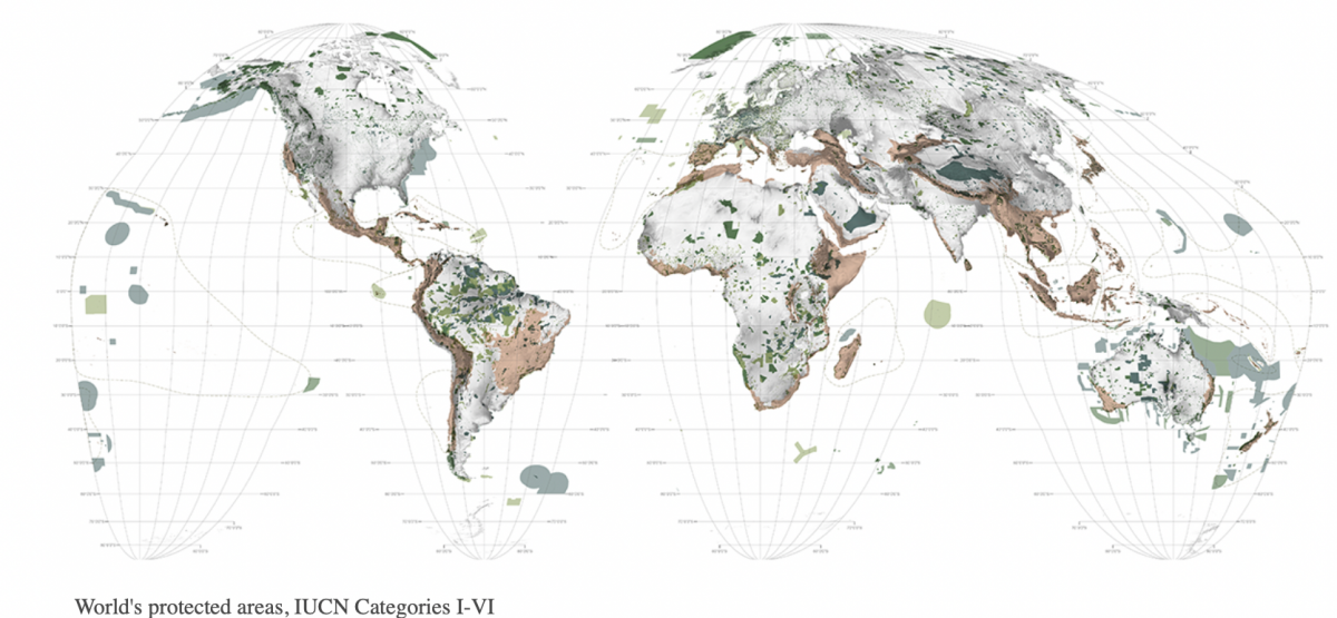
Another team of artist-scientists, landscape architects Richard Weller, Claire Hoch, and Chieh Huang, have been remaking the world’s first atlas, Abraham Ortelius' Theatrum Orbis Terrarum (Epitome of the Theater of the World). Their new atlas is called Atlas for the End of the World. It features a collection of maps and infographics depicting global biodiversity hotspots on a collision course with nearby cities. "A geopolitical tool to help prioritize conservation land-use planning," the maps are intended to help reach the United Nation's goal of 17% protected areas by 2020.
An image of Atlas's protected areas map which is adjusted as new data is produced by satellites circling the globe.
Atlas for the End uses Geographic Information Systems (GIS) to continually update their maps with information from satellites. The gathered data is used to calculate the ‘most-suitable’ future use of each plot of land. However, this wide-angle approach to understanding land fails to account for the individual circumstances of a mapped location; when the alternative future for a piece of land interferes with Indigenous peoples already living there, who should be in charge of the future of the land? When settler behavior, and not Indigenous practices, have endangered the land, would switching the land to its ‘most-suitable’ future use constitute real improvement? Because of these questions, the alternative futures of the protected areas must be viewed as subjective and artistic, rather than unequivocally determined.
Written by Katrina Kish and Esme Allopenna with assistance from Kristin Eshelman


")
![Howard Russell Butler's [Hydrogen prominences]](https://futureoftruth.media.uconn.edu/wp-content/uploads/sites/2921/2023/01/k6584-square.jpg)